Hiking Trails in
the
Porcupine Mountains
Wilderness State Park
Ontonagon,
Michigan
Map of
Trails
LAKE SUPERIOR TRAIL
This trail, longest in the park, follows the
rocky shore of Lake Superior and affords many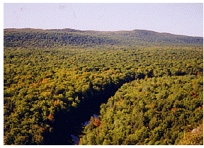 outstanding views. Rugged and remote this trail is among the
Porkie's most challenging. Total trail length 16
miles.
outstanding views. Rugged and remote this trail is among the
Porkie's most challenging. Total trail length 16
miles.
LITTLE CARP RIVER TRAIL
The Little Carp River Trail is among the most scenic in the
park. The turbulent rapids and inspiring waterfalls of the
Little Carp River, and the serene beauty of magnificent
timber makes this a trip to remember. Brook trout fishing is
found along the length of the Little Carp River. Total trail
length 11 miles.
PINKERTON TRAIL
The Pinkerton Trail leads through impressive stands of
virgin hemlock to the mouths of the Big and Little Carp
Rivers 3 miles.
CROSS TRAIL AND CORRECTION LINE TRAIL
These two trails give backpackers access to explore
additional sections of the park.
Cross Trail (total length) 5 miles
Correction Line Trail (total length) 3 miles.
LILY POND TRAIL
Lily Pond is a small trout lake which can be fished
successfully from a boat or other floating device, but is
not safe for wading because of a soft bottom. A fine stand
of virgin pine is near Lily Pond. 3 miles
SOUTH MIRROR LAKE TRAIL
This is the most direct route to Mirror Lake and fine brook
trout fishing. The side trip to Summit Peak is one mile
long. 2 1/2 miles
SUMMIT PEAK TOWER TRAIL
This trail provides an opportunity to visit Summit Peak at
1,958 feet, the highest point in the park. A 40-ft.
observation tower provides an outstanding view of the park
as well as the surrounding area . Wisconsin, Minnesota, the
Apostle Islands, and Copper Peak are a few of the sights
that can be seen on a clear day. A viewing deck on the way
up to the summit provides a panorama of the Little Carp
River valley and ranks as one of the best views of the park.
Summit Peak parking area to Summit Peak Tower 1/2
mile
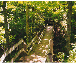
BEAVER CREEK TRAIL
Descending from the Summit Peak parking area and trailhead,
the Beaver Creek Trail joins the Little Carp River Trail 1.3
miles south of Mirror Lake. Bridging and boardwalks allows
the hiker to view and investigate wetlands adjacent to the
Little Carp River as it winds though beaver meadows and
alder thickets. This trail is great for bird watchers and
other naturalists. Beaver Creek Trail to Lily Pond Trail 1
mile.
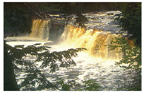
BIG CARP RIVER TRAIL
The variety of scenery on this trail beckons hikers. The
first two miles parallel the escarpment with many
outstanding views. The trail then descends into the Big Carp
River Valley following below the slopes of Miscowabic Peak
and passing by the old Lafayette Mine. Shining Cloud Falls,
highest in the park are about one mile upstream from the
mouth. The river offers many turbulent rapids and brook
trout fishing. Total trail length 9 miles.
NORTH MIRROR LAKE TRAIL
This trail crosses the heart of the 'Porkies' and ends at
Mirror Lake. Surrounded by rugged bluffs and magnificent
pines, at 1,532 feet, it is the highest lake in the park.
Hikers should be in good physical condition to test this
trail as most of the southbound route is uphill. Total trail
length: 4 miles.
GOVERNMENT PEAK TRAIL
The Government Peak Trail is popular with overnight hikers.
The trail follows the Carp River inlet for two miles to Trap
Falls and then west to Government Peak through fine stands
of hardwood and hemlock. At 1,850 feet, Government Peak is
the second highest point in the park. Total trail length 7
1/2 miles.
ESCARPMENT TRAIL
The Escarpment Trail may offer the most beautiful scenery in
the park. The hiker follows the impressive escarpment skirts
over Cloud Peak and Cuyahoga Peak, and descends to the north
end of Government Peak Trail. Sheer cliffs and vista of the
Lake of the Clouds far below will not be soon forgotten. 4
miles.
OVERLOOK TRAIL
This trail offers outstanding virgin timber and many scenic
views: a popular side trip from the Government Peak Trail. 3
miles.
EAST AND WEST RIVER TRAILS
These two trails follow the Presque Isle River, the largest
and most beautiful of the rivers in the Porcupines.
Boardwalk and viewing platforms allow breathtaking views of
this river. Spectacular waterfalls, cascades and rapids are
but a short walk from the parking area. For your safety, no
swimming or wading is permitted in the Presque Isle River.
Be very careful when exploring this area. Take children by
the hand and do not permit them to hike the area without
adult supervision. South Boundary Road to mouth of Presque
Isle River (each way) 1 mile.
LOST LAKE TRAIL
Lost Lake is a small beautiful wilderness lake. The trail
joins Government Peak Trail for a shortcut from the South
Boundary Road to Highway M-107. Total trail length 4 1/2
miles.
UNION SPRING TRAIL
The Union Spring is the second largest natural spring in
Michigan. From the floating dock, view over 700 gallons of
clear water bubble out the ground each minute, a subtle yet
fascinating sight. Total trail length 4 miles.
UNION MINE TRAIL
The Union Mine Trail is an interesting short hike. It
features the Little Union Gorge and history of the Union
Mine. Points of interest are marked by interpretive signs.
Total trail length 1 mile.
VISITOR CENTER NATURE TRAIL
The Visitor Center Natural Trail is a loop trail designed to
orient new visitors, through interpretive stations, to
natural features commonly found in the park. Total Trail
Length 1 miles.
WHITETAIL PATH
Whitetail Path is an access trail allowing campers at the
Union Bay Campground an opportunity to stretch their legs
with a short hike to the Visitor Center. M-107 at Union Bay
Campground to Visitor Center 1 mile.
- For Reservations and Information about
- PORCUPINE MOUNTAINS STATE PARK
- Please Write:
- PARK MANAGER
- PORCUPINE MOUNTAINS STATE PARK
- 412 5 BOUNDARY RD.
- ONTONAGON, MI 49953
- PHONE: (906) 885-5275
-
-
Camping and
Rustic Cabins |
Bears
Wilderness
Tips |
Backpacking
Tips
- MAP
of the Porkies
Lodging
in the Area
Porcupine MountainsInformation
Page
Camping and Rustic Cabinsi n the
Porkies
This is Bear Country
Winter in the
Porkies
Ontonagon
Information Page
Back to U. P. Recreation
Page
Back to the Upper
Peninsula Traveler
Copyright 1998 by Vivian Wood, the
webmaster for Exploring the North, Inc. All Rights Reserved.
Except as permitted under the Copyright Act of 1976, as
Amended, this web site may not be reproduced in whole or in
part in any manner. Unless authorized by the webmaster of
Exploring the North, Inc., reproduction of any web page or
pages on the Exploring the North website for placement on
the internet is a copyright infringement. All right, title
and interest in and to the material on the web pages, the
web site, in whole or in part, and in and to this url and
the urls contained within, is the property of vivian wood,
the webmaster for Exploring the North, Inc. Web site created
on an Apple G-4.
|