Point Iroquois Lighthouse
at the Entrance to the St. Mary's River and the Soo Locks.
This lighthouse stands watch where Lake Superior begins its
treacherous rush into the St.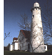 Mary's River. The Ojibwa Indians massacred a group of invading
Iroquois warriors at this location in 1662, giving the point its
original Indian name. It was noted by the early explorers, but did
not become significant until the St. Mary's Falls Ship Canal opened
in 1855. Mary's River. The Ojibwa Indians massacred a group of invading
Iroquois warriors at this location in 1662, giving the point its
original Indian name. It was noted by the early explorers, but did
not become significant until the St. Mary's Falls Ship Canal opened
in 1855.
Ships passing from Lake Superior into the canal came close to
Point Iroquois, through a narrow passage between the sandy shores on
the American side and the reefs on the Canadian side.
The original Congressional appropriation of 1853, provided
$5,000 to build a light either at Point Iroquois or on an unspecified
island in Lake Michigan near the Straits of Mackinac. The Lighthouse
Board decided that the Lake Superior light was more urgent and a
simple wooden house with an attached tower was completed in 1855.
The Point Iroquois Light was first illuminated in 1857 and its
Fourth Order Fresnel lens shone over one of the busiest shipping
lanes in the world: the entrance to the St. Mary's River and the Soo
Locks. Point Iroquois became busier with each passing year, and the
personnel and facilities required to run the station grew
accordingly. In 1870 the house and tower were completely rebuilt, and
in 1902, a two-story rectangular brick house was added to the
residence to provide housing for the assistant keeper at a total cost
of $18,000.
 There was a group
of children at the station and the government sponsored a school at
the point. The children of local fishermen also came here to school,
so the point became a meeting place for local residents. One of the
children who spent nearly all of her childhood at the Point Iroquois
Lighthouse was Betty Byrnes Bacon, and she later wrote a wonderful
narrative of her life at the point, Lighthouse Memories: Growing
Up at Point Iroquois in the 1920s. Betty's story is so
descriptive that you are constantly reminded that this was not only
an official facility, with all of its rules and regulations, but also
an old fashioned homestead, where residents had to preserve food,
chop wood, and pump up cold water to be heated for baths in front of
the fire. There was a group
of children at the station and the government sponsored a school at
the point. The children of local fishermen also came here to school,
so the point became a meeting place for local residents. One of the
children who spent nearly all of her childhood at the Point Iroquois
Lighthouse was Betty Byrnes Bacon, and she later wrote a wonderful
narrative of her life at the point, Lighthouse Memories: Growing
Up at Point Iroquois in the 1920s. Betty's story is so
descriptive that you are constantly reminded that this was not only
an official facility, with all of its rules and regulations, but also
an old fashioned homestead, where residents had to preserve food,
chop wood, and pump up cold water to be heated for baths in front of
the fire.
For over 100 years the Point Iroquois Light performed its
duties, but in 1962 its light was extinguished in favor of a beacon
farther out in the water.
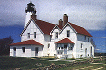
Today, the lighthouse and 65 foot tower have been renovated
thanks to the cooperative efforts of the Bay Mills / Brimley
Historical Research Society and the National Forest Service. It is on
the National Register of Historic Places.
The lighthouse, now a part of the Hiawatha National Forest,
rests on a bluff above Lake Superior, wooden walkways lead to the
beach, and the shore here is littered with unusual driftwood and
banded agates. The large two-story house is white, with a red roof
sloping over all the gables and additions. The attached brick tower,
also white, is topped with a black parapet and lantern room. The
conical tower is 16 feet in diameter at the base, stands 51 feet tall
to the lantern deck and 65 feet high overall. Visitors can climb 72
steps spiraling to the top of the tower for a remarkable view. The
panorama, needless to say, is impressive, as you can see almost the
entire coastline of Whitefish Bay and miles out into Lake Superior,
including any freighter that happens to be passing by. The historical
society has renovated the interior of the house, and antiques and
memorabilia have been arranged to show what life was like during this
lighthouse's heyday. Informative displays fill several rooms, and the
gift shop sells lighthouse theme souvenirs and a wide variety of
books on Michigan's nautical and natural history, including Lighthouse Memories.
The museum and gift shop are open from May 16 to October 7
October 8 to May 14: Lighthouse is closed, but visitors are welcome on the grounds.
Hours:
Tuesday through Saturday:
10am to 6 pm.
Sunday: 1pm to 5pm
Closed Monday
all the Lighthouse at (906)
437-5272
Or visit this website for the Point Iroquois Lighthouse in the Hiawatha National Forest
During summer the summer months, costumed historic interpreters are periodically be on site
to tell the history of the lighthouse and other related topics.
The 65-foot tower is also open to
the public during those times. From its top you have a commanding
view of the sandy shoreline as it stretches out of sight, and of
Canada, across the water to the north.
Directions: In Brimley where M-221 deadends at Lake Superior,
turn left onto 6 Mile Rd. (called Lakeshore Dr. near the lighthouse)
and go about 7.5 miles.
For additional information contact the Hiawatha National Forest
St. Ignace Ranger District
W1900 US 2, St. Ignace, MI 49781
Phone: 906-643-7900
Upper Peninsula Lighthouses
The
Upper Peninsula Traveler
Back to Home
Page: Exploring the North
Copyright 1997 by the webmaster for Exploring the North. All
Rights Reserved. Except as permitted under the Copyright Act of 1976,
as Amended, this web site may not be reproduced in whole or in part
in any manner. Unless authorized by the webmaster of Exploring the
North, Inc., reproduction of any web page or pages on the Exploring
the North website for placement on the internet is a copyright
infringement. All right, title and interest in and to the material on
the web pages, the web site, in whole or in part, and in and to this
url and the urls contained within, is the property of vivian wood,
the webmaster for Exploring the North, Inc. Website created on an
Apple G-4. |