Copper Country Road Trips has
been updated
& filled with Photographs, Maps, and Tours of the
Keweenaw
. . . Past & Present
A Guide to
Michigan's Historic Keweenaw Copper
District
Enjoy Keweenaw History From The
Comfort Of Your Car
by Lawrence J. Molloy
Excerpts from the Houghton - Calumet
Tour Loop; going east on M-26 from Hancock to the outskirts
of Hubbell (Map).
These excerpts are from the original book, Copper Country
Road Trips. The new edition, A Guide to Michigan's
Historic Keweenaw Copper District contains additional
maps, photographs, and information.

(From Hancock,) It may be hard to miss seeing the
Quincy Smelter complex further to your east along M-26, but
it is difficult to find a public spot in which to pull over
and view the site. Some of the best views are obtained from
the public parks on the Houghton shore. Many buildings exist
at the closed, non public site. It may be tempting to
explore the location but winter storms have taken their toll
and it is not safe to go past the 'No Trespassing' signs and
enter the area. There is an effort to try to acquire the
site in order to save some of the structures and incorporate
them into the Keweenaw National Historic Park.
From 1898 to 1967 the Quincy Mining Company smelter at
Ripley smelt copper first from its mines and then later from
its reclamation plant. The smelter complex is built on the
stamp sand of the Pewabic mines' mill. The smelter continued
to melt scrap copper until 1971. Among the buildings
remaining on the site are the three-story blast furnace, or
cupola, the 1898 furnace 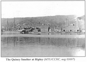 building
with its 1904 addition to house additional reverberatory
furnaces, and a 1910 addition to house an automatic casting
machine. The sandstone faced, mineral warehouse was built in
1904. It was reached by a 460-foot trestle. The site also
includes three rectangular warehouses, a concrete block
briquetting plant that was built in 1906, three small
warehouses, a powerhouse, a casting house, carpenter and
cooper (barrel making) shop, machine shop, and laboratory. building
with its 1904 addition to house additional reverberatory
furnaces, and a 1910 addition to house an automatic casting
machine. The sandstone faced, mineral warehouse was built in
1904. It was reached by a 460-foot trestle. The site also
includes three rectangular warehouses, a concrete block
briquetting plant that was built in 1906, three small
warehouses, a powerhouse, a casting house, carpenter and
cooper (barrel making) shop, machine shop, and laboratory.
About 3/10 of a mile from the smelter on M-26, in
Ripley, you'll find the Mont Ripley Ski area, the site of
the Franklin Mill and Tram Road. In the winter the parking
lot is full of cars, but in the summer you have a chance to
pull in and get a view of the Franklin Mining Company Mill
site and tram road. The Franklin mine was just north of the
Quincy. To go from their mine to their stamp mill, which was
not too far from the parking lot nearer to the Portage Lake
shore, the Franklin Mining Company had a gravity powered,
dual car, tram railroad. Like the Quincy and Pewabic trams
the loaded car going down pulled the empty car up the hill.
 As
you leave Mason (about 4/10 of a mile) you'll see the Quincy
Mill on your left across the road and the Quincy Dredge
Number Two on the shore on your right. Tour busses have been
known to pull over on the wide road shoulder in this area to
let visitors view the dredge and mill area. The large, box
like vessel beached on the shore is a mining dredge. The
sand it sucked up and sent to land was dumped into the lake
years earlier as a waste product of milling. The Calumet
& Hecla Mining Company used this dredge (Dredge Number
One) at their Lake Linden Reclamation Plant. It could
process over 10,000 tons of sand per day. Built in 1913, it
has a 141' suction pipe that could work 115 feet below
water. In 1951 the Quincy purchased the dredge and it became
known as Quincy Dredge Number Two. This proved to be
excellent foresight, because Quincy Dredge Number One sank
in a storm in January 1956. Quincy Dredge Number Two was
used at the Mason reclamation facility until 1967. As
you leave Mason (about 4/10 of a mile) you'll see the Quincy
Mill on your left across the road and the Quincy Dredge
Number Two on the shore on your right. Tour busses have been
known to pull over on the wide road shoulder in this area to
let visitors view the dredge and mill area. The large, box
like vessel beached on the shore is a mining dredge. The
sand it sucked up and sent to land was dumped into the lake
years earlier as a waste product of milling. The Calumet
& Hecla Mining Company used this dredge (Dredge Number
One) at their Lake Linden Reclamation Plant. It could
process over 10,000 tons of sand per day. Built in 1913, it
has a 141' suction pipe that could work 115 feet below
water. In 1951 the Quincy purchased the dredge and it became
known as Quincy Dredge Number Two. This proved to be
excellent foresight, because Quincy Dredge Number One sank
in a storm in January 1956. Quincy Dredge Number Two was
used at the Mason reclamation facility until 1967.
Across the road from the dredge are the Quincy Mills.
Construction began on this site in 1888 to replace the
original Quincy Stamp mill on Portage Lake. The mill began
with three stamps (hammer like devices used to crush rock)
and two additional were added in 1892. The mill site
 closest
to the dredge contained the 1890 mill. It was modified and
additional buildings were added over time. The square
building adjacent to it was a turbine building. As
production increased, Stamp Mill Number Two, with three
stamps, was built to the north of the Number 1 mill in 1900.
Perhaps the best time to see the Number Two mill is in the
early spring or fall when the view from the old railroad
grade above the site provides an nice overview unobstructed
by the summers' brush. closest
to the dredge contained the 1890 mill. It was modified and
additional buildings were added over time. The square
building adjacent to it was a turbine building. As
production increased, Stamp Mill Number Two, with three
stamps, was built to the north of the Number 1 mill in 1900.
Perhaps the best time to see the Number Two mill is in the
early spring or fall when the view from the old railroad
grade above the site provides an nice overview unobstructed
by the summers' brush.
Approximately 6/10 of a mile from the Quincy Dredge
look carefully at the waters of Torch Lake. The small object
sticking out of the water is a sunken dredge. It is all that
remains visible of the Quincy Dredge Number One, the
original dredge purchased by the Quincy Mining Company that
sank in a storm in January 1956.
After you've driven about 2 miles from the Quincy Mill
you'll see the road curve and a sign near the curve says
Tamarack City. Some maps refer to it as Tamarack Mills. On
your right are some waste sands and on the left a solitary
home in front of some cement foundations. It might not seem
like it by the quiet nature of the spot, but three large,
noisy, stamp mills were located within 3/10 of a mile of
this sign.
Across the road about 3/10 of a mile before the sign
was the Osceola Mining Company Mill. The original, wooden
stamp mill was built by the Osceola Mining Company in 1886.
It was demolished in 1905. A second mill was built in 1899 and a
third built in 1902. This last mill, had 4 compound steam
pressure heads made by the Nordberg company, similar to the
one still remaining at the Ahmeek Mill just up the road. The
mill adjoins the Tamarack Mill as both companies shared
management and facilities.
demolished in 1905. A second mill was built in 1899 and a
third built in 1902. This last mill, had 4 compound steam
pressure heads made by the Nordberg company, similar to the
one still remaining at the Ahmeek Mill just up the road. The
mill adjoins the Tamarack Mill as both companies shared
management and facilities.
The white building just before the sign, across the
road, behind the house, is part of the Lake Mill Number 2.
The Lake Milling, Smelting, and Refining Company was long a
factor in milling and smelting in the Keweenaw. They had
many buildings in the area.
The large concrete foundations across the road are the
remains of the Tamarack Mining Company Mill. After first
leasing part of the Osceola Mill. Tamarack began building
its first mill here in the summer of 1886. A second mill was
added in 1896. As the Tamarack shared owners with the
Osceola, the Osceola and Tamarack mills shared features such
as a common pump house. A reclamation plant was also built
on the site. The mills worked until 1917 when the Tamarack
merged with the Calumet and Hecla. C&H eventually
acquired control over most of the copper companies in the
Keweenaw. C&H dismantled the mills here in 1920 to
consolidate their operations.

It's easy to find the only remaining steam stamp in
the Keweenaw. It's just up the road, on the right side of
the road in Tamarack City. The Ahmeek Mill with its Nordberg
Compound Stamp is easy to visit and photograph. The Ahmeek
Mining Company had four of these steam-powered stamps
installed in 1910, and four additional stamps were added in
1914. The large superstructure that covered the stamps can
be seen in the accompanying photograph. A trestle, still
visible between the trees across the street from the stamp,
brought rock to the mill above the level of the stamp. The
compound - expansion nature of the machine represented a
major improvement in processing of copper ore. Approximately
104 24 inch blows could be struck by the stamp per minute.
The mill could process approximately 7,000 tons of ore in a
24-hour period. This is one of the few places where a
compound steam stamp may be seen in its original position.
Another of the stamps from this mill did survive the scrap
bin and is now on display, at ground level, in a mining
museum in Colorado. While you are in Tamarack City you may
notice a sign to Hungarian Falls. The upper and lower
portions of this falls are about 3/4 of a mile west of town.
(Follow M-26 into Hubbell).
A Guide to Michigan's Historic Copper
District
(formerly Copper Country Road Trips)
Enjoy Keweenaw History From The Comfort Of Your Car
by Lawrence J. Molloy
May be purchased for $29 including shipping and
handling from
U.P. Candle Company
Gitche Gumee Landing
202 Ontonagon Street
Ontonagon, Michigan, 49553
Phone: 906-884-6618 or Fax: 906- 884-6753
E-Mail
Richard Whiteman at Great Lakes GeoScience for more
information
Back to a description of the book A
Guide to Michign's Historic Copper District
Enjoy Keweenaw History From The Comfort Of Your Car
Text and black and white pictures from "Copper Country
Road Trips", reprinted with permission of Lawrence J.
Molloy. Color pictures by Exploring the North, Inc.
MTU/CCHC after photos indicates that the pictures are
from the Michigan Technological University Copper Country
Historical Collection.
Books
about the Upper Peninsula
Keweenaw
Peninsula Information
Specialty
Products of the Upper Peninsula
Shopping
in the Upper Peninsula
Back
to the Upper Peninsula Traveler
Back to Exploring the
North
Copyright 2001 by vivian wood, webmaster of Exploring
the North and Lawrence J. Molloy . All Rights Reserved.
Except as permitted under the Copyright Act of 1976, as
Amended, this web site may not be reproduced in whole or in
part in any manner. Unless authorized by the webmaster of
Exploring the North, Inc., reproduction of any web page or
pages on the Exploring the North website for placement on
the internet is a copyright infringement. All right, title
and interest in and to the material on our web pages, the
web site, in whole or in part, and in and to this url and
the urls contained within, is the property of the webmaster
for Exploring the North, Inc.
|